Paleoshorelines indicative of multiple high lake stages can be found around many lakes on the Qinghai-Tibetan Plateau (QTP). Conspicuous paleoshorelines associated with the most recent highstands can be readily observed on satellite images and during field investigations. However, earlier paleoshorelines have been identified at only a few sites around these lakes due to a lack of clear shoreline features and limited spatial extension of those that can be identified. We investigated past lake highstands using published chronologies, Aster-DEM, Google Earth, and ArcGIS 9.2 software. These data suggest that (1) paleoshorelines of the most recent lake highstand were formed during the Holocene; (2) during this highstand, lake levels reached more than 90, 60–90, and 30–60 m higher than present in the central Gangdise and western Qiangtang areas, while in the eastern Qiangtang, Holxil-Yushu, and northeastern QTP areas highstands did not exceed 30 m above modern; (3) during the early Holocene, some lakes on the southwestern QTP combined to form large lakes, while lakes in the inland areas of the QTP were only a little larger during the Holocene high lake level stages.
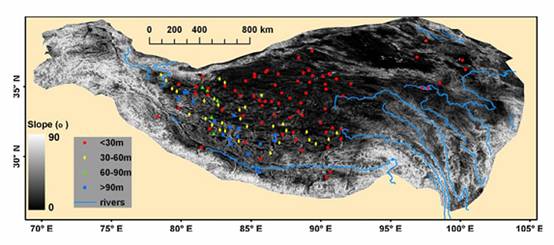
Distribution of lakes on the Qinghai-Tibetan Plateau showing the height of the highest continuous shorelines above present lake surfaces relative to slope. (Photo from the original paper)